Following our introductory article on Naava Sastra, we determined that a sequel was required for this Set of posts on Indic Shipping & Navigation. The previous article provided a general overview of the history and principles.
This particular article will focus more on the Science of Navigation & extract greater insight into key historical episodes.
Introduction
Sailing the Oceans or even rowing the rivers involves more than just setting a course and letting the winds carry you where they may. It requires a deep, experiential and often scientific knowledge of not only the geography, the waters, and the weather, but even the stars.
Among the great navigators of the world, it is the Phoenicians, Egyptians, Greeks, Vikings, Spanish, and british who are typically named and numbered. Very rarely do we hear of the exploits of Indian sailors. Ironically, Sinbad is often named as an Arab navigator due to the dominance of the dhow in late antiquity, but as the name indicates, he is in fact often traced to Sindh.
Sindhu desh was famed not only for the speed of its horses or the beauty of its women, but also the the skill of its sailors and worship of Varuna (whom they name, even today, as Jhulelal). Those who plied the monsoon winds both West and East would know very well how to traverse the seas based on the stars.
Terminology
- Samudhrasamyaana—Navigation
- Thaataka—Water Tank
- Samkrama/Sethu—Bridge/Causeway
- Vahithra—Ship
- Naava—Boat
- Nauka—Small Boat
- Plava—Skiff
- Karmavarga—Crew
- Dhala—Squadron
- Bala— Fleet
- Brhannausaadhana—Armada
- Naava Sena—Navy
- Naavaadipathi (Nauvaaraka)—Chief Admiral/Admiral of the Navy
- Balaadheesa—Fleet Admiral (i.e. Eastern/Western Fleet)
- Dhalaadheesa—Squadron Commander
- Chaalaka/Naavapathi—Captain
- Upachaalaka—Lieutenant
- Naavaka/Naavikaa—Sailor
- Naavin /Shambin —Boatman/ Rower
- Karmavarga—Crew
- Niryamaka— Steersman/Ensign
- Dhattarsmi/Rajju-grahaka—Rope & hook handler
- Saasaka—Instructor
- Utsechaka—Bailer
- Marjaka— Sweeper
- Dheevarah—Fisherman
- Theeram—River bank
- Samudhratha—Coast
- Paryavarodhah—Blockade
- Mathsya Yanthra—Compass
- Raaja Yanthra—Astrolabe
- Dhisha/Dhik—Direction
- Poorva/Prachee—East
- Paschima/Prathichee—West
- Dakshina/Avaachee—South
- Uttaraa/Udeechee—North
- Aisaanee—North east
- Aagenyee—South east
- Nairrthaa—South west
- Vaayavyaa—Northwest
- Vaathavarana—Weather
- Prabhanjana—Storm
- Vela-kaala—Time of Day
- Purvaahna—Forenoon
- Madhyaahna—Noon
- Aparaahna—Afternoon
- Pradhosha—Evening
- Ardharaathra—Midnight
- Prathyushas—Dawn
- Rtu—Seasons
- Vasantha—Spring
- Greeshma—Summer
- Praavrtha—Early rains
- Vaarshika —Rains
- Shaaradha—Autumn
- Hemantha—Winter
Navigation
Navigation is not a simple matter of knowing the cardinal directions and setting sail. It requires a compass, a starmap, and often an advanced instrument like an astrolabe. Ancient India had all of them. Following the fall of Sindh to the Arabs, the mantle of Hindu navigation in the West was more prominently taken up by those most commercial of traders, the Gujaratis.
“Thor Heyerdahl talks of an overseas trade contact between the ports of Gulfs of Cambay and Kutch with the islands of Maldives, and the coats of South India, as early as 1500 B.C. Buddhist jataka tales, like the Baveru and Suppara jatakas talk of Indian sea trade with Babylon and African shore areas. Other jataka tales and Kathasarit Sagara talk of coasting sea links between Gujarat and Srilanka on one hand and across-the-sea-voyages in the Bay of Bengal and beyond.” [1, 1]
Indeed, the Buddhist Jatakas here are illustrative, in the science of navigation (samudhrasamyaana) specifically.
“Jataka Mala belonging to fourth century BC to first century AD refers in his allusions to Suppara Jataka and the attributes of an ideal pilot it mentions. The Bodhisatva was in those days an accomplished pilot who knew the courses of the stars and their path orientation. He would never ignore any pilot who knew the courses of the stars and their path orientation. He would never ignore any weather condition; he could distinguish regions of the sea by fish life, colour of water, nature of sea-bottom and depths, birds and coastal features. He was one with a sharp memory and a strong character, and had great abilities in guiding the vessel to the right destination in safety, even foul weather.” [1,5]
“Early navigation pilot guides of Indian Ocean waters could have existed in the period of the Pallavas and Chalukyas (6-7 Cent. AD), according to Chinese references. Marco Polo, towards the end of the 13th Cent. AD, spoke of the Chola pilot and sea-charts, while the Egyptian Fatamid and Mamluk period documents also talk of the Chola system of Navigation. Both Ibn Majid and Suleiman al Mahri make repeated references to the Chola model of navigation…G.R.Tibbets concludes that the second part of the Seventh Faida of the Fawaid drew heavily on the Chola pilot book.” [1, 5]
Those educated at jnu, ashoka, and amity (not to mention Lovely University…) may be quick to giggle & gaggle like aaptards…but wait…there’s more.
“Ibn Majid states that on the Coromandel Coast and Bay of Bengal, the navigational data of the Cholas is most reliable, though he himself differs to a small extent. Al Mahri, on the other hand accepts the Chola nautical data in toto and states that there is no need for independent measurements in the Bay of Bengal.” [1, 5]
However, the Tamil Cholas were not the only navigational sources held in high regard. In the western sea (Apara Samudhra), it was the Gujarati and later Marathi mariner who reigned supreme.
“The-Kutchi-Gujarati texts are locally called Pothis. The language used is a coastal Kutchi dialect of seamen, written in Gujarati script. Written down by none-too-literate seamen, these are not scholarly treatises…These manuals often refer to a mother-text, called the Sankhodhar Pothi. It is believed to be a manual of pirates of Beyt island in the Gulf of Kutch. This text, however, is not traceable. ” [1, 6]
“The following are the essentials of information in these texts: 1) Almanac of panchang data, such as the regional calendar months, their Hindu, Arabic equivalents…2) Stars and constellations used in navigation for measurement of azimuth, altitude identified by their local names and their positions in the sky in relation to months and seasons. 3) Stars used for direction compass cards and rhumb line sailing. 4) Empirical wisdom of sea-conditions, under-water dangers, sea-life, waves, tides, currents, littoral drifts, and depths. 5) Empirical wisdom of sky conditions, wind, cloud identification, foul weather premonitions and emergency actions for bad weather”. [1, 8]
#5 is often neglected by today’s “All is well” 3 idiots brigade and their “chalta hai” attitude, aur “hunooz delhi door ast” doston. Planning, preparation, precaution, and preemption are all far better than perennial presumption amongst our plaudit-hungry “pundits”.
Captaining and controlling a vessel is not for the lackadaisical or light-hearted. A great deal of concentration and responsibility must be maintained when the obligation of passengers and expensive cargo is taken on.
“The word ‘navigation’ literally means driving a wate-rcraft-‘navis’ a ship and ‘agere’ to drive. Navigation pertains to the mode of conducting a watercraft safely from one shore to another. In a broad sense, it embraces not only finding the way, but also handling and maneuvering the craft away from natural dangers and hazards. Hence, navigation comprises the delineation of a voyage route, conducting the vessel along the designated route and finding the position of the vessel from time to time, to check its progress. Time-keeping is an integral part of this package.” [1, 12]
As a result of this, Weights & Measures is a foundational part of proper navigation. Fortunately, ICP has you would-be navigators covered here via topic of Pauthavam.
“Early classical Sanskrit and Tamil literatures speak of special time keepers in royal courts and of a device in the form of a water-glass to calculate the span of a ghatika or naligai. No doubt the usage of a sand glass in the sail boats of the Indian Ocean is known to measure current and boat speed” [1, 14]
“A smaller unit in usage among the sailors is the ghatika or naligai (in tamil), 7.5 ghatikas (three hours) making a zam and 60 making a day” [1, 14]
“Invariably all Indian sailor records/manual books carry meticulous details of the day of commencement of voyage/record keeping, stating the lunar month, the fortnight, the tithi and at times the day of the week, and the nakshatra (the asterism in which the moon lies in its orbit on the day) apart from the year, in the locally reckoned era thus:
“Book completed at Muscat Fish Market – Taken down from Sikotra Atajan Pir Ujhadada in Samvat 1929 (AD 1872), Sravan Sudh 9, Navami, Saturday” (in Kutchi).” [1, 16]
“Depth of Water is yet another sea-attribute that is qualitatively as well as quantitatively expressed. Early estimates of depth are based on discoloration of water-greenish or pure blue for deep waters, becoming progressively brownish to reddish brown in shallower waters, obviously due to sediment content. A simple unit of depth used all along the Indian coasts is the height of an average adult man…tan or wam on Gujarat and Konkan coasts, maar or pagam in Tamil and Malayalam, bar or barlu in Telugu and Oriya, and bam in Bengali, it is a length equivalent to the later day mariner’s fathom, nearly 1.8 meters. In local linear measurement, it is equal to 4 cubits (muzham/kara/hath).” [1, 17]
As a comparison point to modern standards, here is the US Survey System:
US Survey
- 33/50 ft. or 7.92 in. 792/3937 m or 20.117 cm
- 1200/3937 m or 30.48006 cm[10]
- 25 li. or 16.5 ft. 19,800/3937 m or 5.029 m
- 4 rd. or 66 ft. 79,200/3937 m or 20.116 m
- 10 ch. 792/3937 km or 201.168 m
- 8 fur. 6336/3937 km or 1.609347 km[10]
- 3 mi. 19,008/3937 km or 4.828 km
International Nautical
- 2 yd. or 6 ft. 1143/625 m or 1.8288 m
- 120 ftm. or 1.091 fur. 3429/15625 km or 0.219456 km
- 1.151 mi. or 8.439 cb. 1852 m or 1.852 km[10]
Equipment
“The magnetic compass, the sextant, the station-finder, the nautical chart and sounding techniques all came into use one after the other to meet the necessities. Improved versions of efficient sails, central axial stern rudder and sturdy anchors also evolved about the same period.” [1. 13]
“marathi literary references exist indicating south pointing Maccha Yantra – a magnetized iron fish floating freely in a disc of oil” [1, 22]
Speed of current is measured using a tappu (which ostensibly is a corruption of the tamil word mitappu, meaning to float). This mechanism consists of a palagai (wooden plank) and a rajju (length of measuring rope). The rope is 500 feet/170 m long, with knots at 10 specific intervals. [1, 23] The status of currents (neera neela) is gauged by observation of the flows.
“In estuarine waters, tidal lagoons and near-shore waters, paddle boats as well [as] sailing vessels readily estimate depth by use of a pole of standard length normally about 6 metres. The pole is invariably a bamboo or casuarina or split coconut of a length 16 hath, like the malabari baunsa or tamil oda-kol.” [1, 17]
“Direction is a navigational parameter that is sought to be determined as precisely as possible…During the night, east and west are evaluated in relation to the waxing/waning phase of the moon, and the direction to which the crescent horn of the moon points or from the convex side.” [1, 18]
“The same wind often gets named differently in different sections of the same coast. For example, on the Tamil coast; Kodai is the same as Kacchan, Kanni the same as Chola Kacchan and Ela Katru the same as Chola-Kondal…A distinct association is noted between prevalent/dominant wind from specific directions and weather: e.g. Varsha katru as known in Malabar and Lakshadweep for the strong monsoon wind from the south-west, the Kondal in Tamilnadu for the could-bearing easterlies, the Toofan Surya Varo of Kutch, the Seethagalli (Cold Wind) of Orissa and Andhra.” [1, 20]
Oft-ignored as an appendage of the Kathiawar, the land of Kutch has its own distinct identity and language (Kutchi). The people are very much at the tri-junction of Rajasthani, Gujarati, and Sindhi cultures, and possess enterprising aspects of all 3: the desert caravan, sea-borne tradition, and the lively raas-garba dance & dress.
Extracts from the Kutchi manuals stipulate when to avoid sailing in particular routes. Generally speaking, monsoon was a no-go time depending on direction.
“Taking the prevalent weather, wind, current and littoral drifts into consideration, the duration of the envisaged voyage and the normally expected weather changes in the carted route area, the Indian seamen have worked out their voyage time schedule by the sheer wisdom of cumulative experience. The peak of the S.W.monsoon-July, August-is a period of stay at home and almost all sailing traffic comes to a close just before the setting in of the monsoon. This is the most dangerous period to approach the west coast of India, Bengal or Myanmar. The end of the monsoon heralds the commencement of the a fresh voyaging season and is accompanied by the festivals of the Nariel Poornima in the Sravan month.” [1, 115]
“Sailing season for Konkan, Goa vessels ends by May 10. They will not leave for Gujarat or Malabar after April 20 and for Kutch after end of March.” [1, 116]
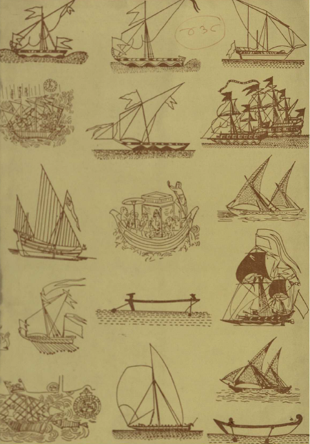
Vessels
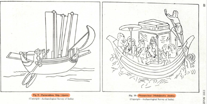
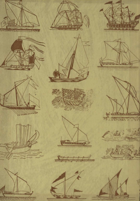
Ships the world over come in a variety of shapes and sizes. The early Indus & Sumerian reed boats would later be exceeded by the Greek biremes and triremes. Viking long-ships would later make their mark as would massive Chinese junks. Then followed the Portuguese man-of-war and the Spanish galleon. Indeed, it was the european mastery of the sea that made the collective west subcontinent the superpower of world. The later english frigates and galleys would face off against a variety of Indian ships (vahithra), boats (naava), and even naukas (small boats).
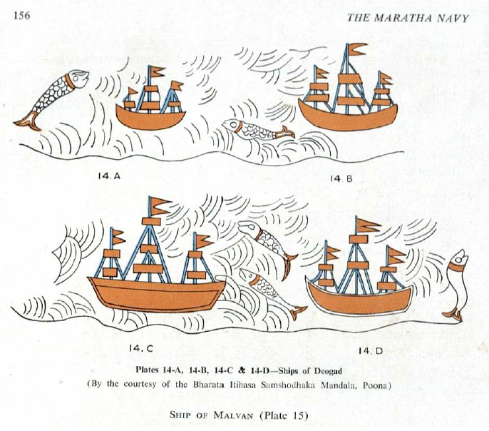
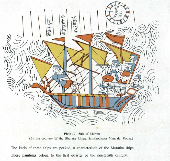
If the first article in our set focused on Paramara Bhojas texts on various vessels, this one will provide a view of the various Maraattha warcraft that delay british imperium by a century.
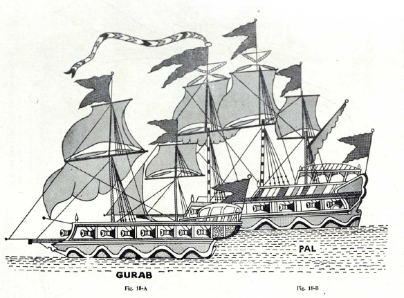
The mainstay of the Maraattha navy were the Pals (3 masted vessels) & Gurabs (2 masted).
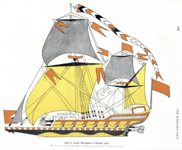 However it was the nimble Galbat warboat that would prove to be the most lethal in the shallow waters of the Indian coast.
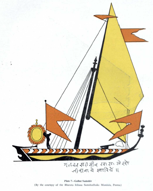
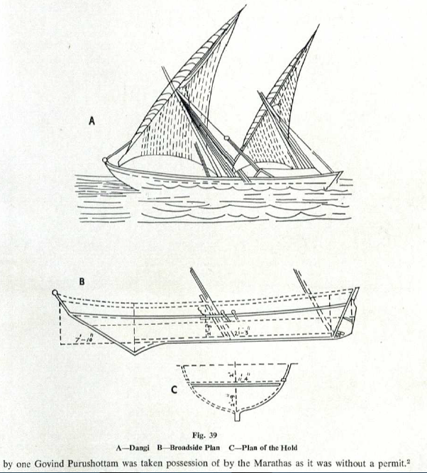
There were other vessels, of course. However, unlike the Vahithras & Naavas above, these were more akin to Naukas and Plavas. The first was the Dangi.
The second was the Baggala.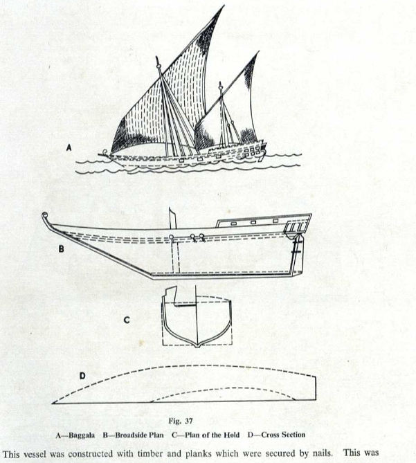
Warfare
The Maraattha Svaraajya was envisioned as the Successor to the South’s Vijayanagara empire.
Key Ports of the City of Victory included Bhatkal and Honavar on the West Coast and Nagapattinam on the East Coast. Periodically the Rayas would rule as far as Machilipatnam and Krishnapatnam. Indeed, Krishna Deva Raya sacked Golkonda itself in the 1500s. However, the greatest ruler of Hampi would in fact be exceeded in the seas by 1 of his predecessors.
“Another notable achievement of Devaraya II was the successful naval expedition against Sri Lanka under the leadership of Lakkanna. The Sinhala ruler paid huge indemnity to Devaraya. For this achievement Lakkana was given the title Dakshina Samudradhiswara.” [2, 106]
Nevertheless, it is Chhatrapathi Shivaji Bhonsle who is credited with reviving the all-India Navy, not truly seen since the heady days of the Imperial Guptas and The Maurya Empire. The Chola Empire certainly fielded a Blue Water Navy, but its focus was on the East, at a time when it should have taken up civilizational responsibilities in the West. Just imagine the expeditionary force that Rajendra Chola could have (and should have) led not just to Lanka, but to liberate occupied Sindh itself.
This is echoed elsewhere as well. [4]
“If the Cholas had their conquests on the sea, Shivaji was the first ruler in India to realise the potential of the navy. Unlike most other empires, Shivaji’s navy was not only for trade—its brief was political, rather than economic.” [4]
“There were the Portuguese, who controlled the Arabian Sea, the English and the Siddis, who were a dangerous enemy. Shivaji’s naval ambitions started in 1665 with the loot of Basrur, located in Udipi district of Karnataka. He attacked Basrur with 85 ships big and small, and brought home immense booty. No naval engagement took place in this raid. But it was the turning point.
Shivaji’s ambitious naval plan made even the Portuguese jittery.” [4]
It is for this reason that The Bhonsles are put in the top echelon.[5] Empire-building is great, but National & Civilizational Liberation is better. Shivaji Raje laid the foundation for precisely that.
“In February 1665, he decided to test the preparedness of his fledgling navy. With 88 ships, including three large ships, he embarked with 4,000 infantry and raided the seaport of Basrur. En route, his convoy passed close to the Portuguese possessions at Goa which wisely kept away from the powerful Maratha fleet.” [5]
“By 1680, the Maratha navy had become a formidable force and had 45 large ships (300 tonnes), 150 small ships and over 1,100 Galbats (small boats).” [5]
The early admirals helped train the nascent Marathi sailors; however, the Maraattha Navy would not come into its own until one of its own was at the helm. It was the Angre family that truly helped this green-water force truly become a fearsome blue-water battlefleet. Tukoji, Kanhoji, and Tulaji would successfully make the naval force their family fiefdom.
” Appointed sarkhel or admiral of the Maratha fleet in 1699, [Kanhoji] Angre has the rare distinction of never losing a naval battle. “In 1710, the sarkhel was in control of the entire west coast from Mandwa to Goa,” writes Ruby Maloni in her paper The Angres and the English—Contenders for Power on the West Coast of India in the Indian History Congress Vol 66. “The British historian of the Marathas, Grant Duff ranks the Angre navy first and the English navy second, in this period,” she writes.” [5]
In the first year Angre took over, he defeated the Portuguese, the English and the Siddis, and annexed Sagargarh, near Alibaug. He made Vijaydurg his capital in 1720 and his maritime empire continued to grow. His enemies continued to attack for three years.
At its peak in 1729, Angre’s fleet had nearly 100 ships. They were commanded by Kolis, but he held forth and insisted on collecting Chauth—25 per cent tax on revenue.” [5]
So if the Angres were so successful, what happened? All one need do is to study Indian internal politics (the most nationally treacherous in the history of humanity…) to find “chanakya-niti!” striking again.
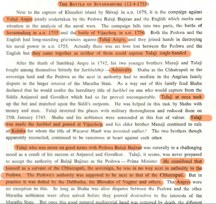
“Right from 1749 onwards, the Peshwa had initiated talks with the British to carry out a joint operation against Admiral Tulaji Angre. On March 19, 1755, the Peshwa and the British signed an agreement to carry out joint operations. The two navies were to operate under a British commander” [6]
“The battle resulted in the burning of one large fighting ship of 74 guns, eight gurabs of 200 tonnes and 60 galbats. On an average, a gurab cost anything up to Rs 1,200 and took nearly one to two years to build. This loss crippled the Maratha navy decisively and they could never match the British strength after this. The British captured war booty worth £130,000 worth of gold, silver and precious stones. Also captured were 250 guns, six brass mortars and huge quantities of ammunition. The British were not content with just the destruction of the ships; they also set fire to the shipyard. The Peshwa and the Marathas were kept out. Even Vijaydurg was handed over to the Marathas after many requests and long delays. The British clearly outwitted the Marathas. “
“Marathas” here clearly means the outwitted Peshwa Nanasaheb. So much for self-proclaimed [j]enetic “high iq” [j]eeniuses…
Conclusion
Navigation and its history in India is a simultaneously complicated and intriguing topic. On the one hand is the science of seafaring itself, and on the other, are the exigencies of driving away seaborne invaders.
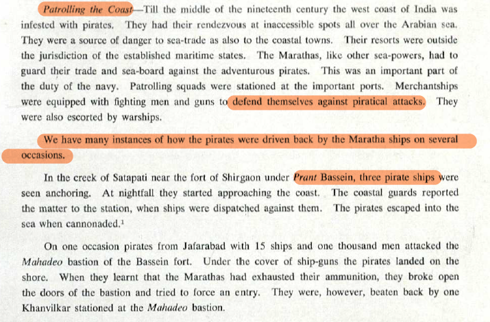
For all the talk of Angrian Pirates and Piracy in India, the Kakatiyas and Maraathas were in fact known for suppressing piracy.
The Maladministration and (de facto) misrule of Balaji Bajirao, a.k.a. Nanasaheb Peshwa, reflects poorly on the de jure authority of the Maratha Empire—the ruling Bhonsle Chhatrapathi. Indeed, from the battle of Vijaydurg to Panipat III, caste supremacists naturally gloss over all of Nanasaheb’s poor decisions as failure to understand his (and the peshwai’s) self-proclaimed “genius”. Where is the genius in destroying one’s own aligned navy (even if it is from a rival)?. Where is the genius in an army commander permitting thousands of civilian campfollowers wishing to go on teerth yatra, on the eve of Panipat III?
Why keep the accursed nizam on his throne, with large swathes of Marathwada still in his hands?—tributary though it was, the misrule of the asaf jahs continued due to the Shrivardhan Bhats, who themselves prolonged the unnecessary civil war following Shahuji Bhonsle’s release from mughal captivity. This destabilised the rightful rule of and unseated the very Maharani Tarabai who had won Svaraajya for the Maraatthas by 1710. Much time, blood, and treasure was expended in an unnecessary civil war on account of these newcomers from the coastal & foreign-plagued konkan, who quickly displaced deshastas like Moropant Pingle and others who had formerly served as peshwa. Innocent braahmanas should not pay for the crimes of kapalikas.
https://x.com/MacroViewpoints/status/1296463881653583875
Those who protest, asserting that Tulaji defied Peshwa authority must remember that authority legally rested with the Chhatrapathi. Tulaji’s point was that he was equal to the mere minister and reported directly to the Chhatrapathi. In a later age, the Barbai got fed up with Peshwa antics of the Shrivardhan Bhats, and put them in their place by unseating them. The result? The open traitor Peshwas Raghunath Rao & Narayan Rao signed treaties of subsidiary-alliance and became slaves of the british after being punished and defeated by the Maratha Barbai. A minister, even Prime Minister, is subordinate to the King—not the other way around.
Even considering that the more centralised approach of the Balaji Bajirao might be necessary, he failed to follow the example of Chhathrapathi Shivaji himself. Raje, when faced with his insubordinate brother at Tanjore, chose to leave him in place rather than risk fratricide. After all, own-side rival at least provides inertia or even opposition to other-side national & civilizational enemies. Nanasaheb Peshwa not only engaged in fratricide, but sabotaged the Maratha navy (painstakingly built by Bhonsles & Angres) and he allied with the English—helping the EIC and Portuguese gain ground after being stymied.
https://x.com/MulaMutha/status/1294304897534324736
The true fall of the Maraattha empire (and colonisation of India) can be traced not to 1808, not to Panipat III, but to Vijaydurg 1756, and the gutting of the Maraattha Navy by this treasonous action of the Peshwai. On what basis should a mere prime ministership be hereditary? Whether it was the patriotic Maraatthas or the tyrannical, terrorist Tipu, both local rulers admitted that they could never defeat a power that had control of the sea. India’s slavery & humiliation can be traced to the battle of Vijaydurg.
Per Hanlon’s razor, it is said, “Never attribute to malice what can be adequately explained by stupidity”. In reality, if the stupidity is so consistent, one can only begin to suspect malevolence. This willful destruction of Maratha naval power paved the way not only for the british to dominate the seas of India, but also permitted the piratical Portuguese (almost neutralised at this point) to go on the offensive and take Dadra Nagar Haveli. So much for Peshwai apologists proclaiming “Tulaji’s punishment had no yeffect on Navy!!”.
https://x.com/MacroViewpoints/status/1296462197300789249
The stupidity and cupidity of the aristocracy (evident even in Vijayanagara, Mewar, and the Maratha Swarajya) was exceeded only by the maniacal treachery of ministers who always managed to escape mrtyudand because…gaste. The irony is, whatever the fashion post-Chanakya, the dharmic ministries are the realm of kshathriyas and mixed castes precisely because they can be executed for treason. Whatever their treasonously stupid greed, they can be held to account.
What happens when a “ritually pure” minister turns traitor? What is a king to do? Sambhaji Raje faced the very same false grievance—and he was betrayed for actually protecting the kingdom by executing traitors (regardless of caste). That is why those who demand varnashrama dharma privileges should limit themselves to varnashrama dharma responsibilities. Those who wish to live in modern republics must do the business of the public—or be prepared to be held to account.
Digital duncecaps and their real (and reel-life) alter-egos are quick the cut down Maraattha achievements in the name of their self-sabotaging caste conflicts. The obligatory mockery by the West aside, even the Blockbuster film franchise and kitsch extravaganza called Pirates of the Caribbean, featured an Indian sailor mentioning Sambhaji (presumably the Angre).
In fending off one’s rival, it is imperative not to undo one’s own greater ethnic and civilizational cause. The talent of Tulaji Angre was recognised by noneother than the british, who placed him as the first rank admiral of that era.
When even your enemy recognises that you did him a favour by ruining your rival (and the enemy’s obstacle), it’s clear how much more of a moron you and your supporters truly are. All the more reason why chanakya and chanakyanism should no long be used to navigate politics, let alone the coasts. Sri Krishna was always a better guide for the soul, and the sea…
https://x.com/ShreyasTambe1/status/1731961512565076341
References:
- Arunachalam, B. Heritage of Indian Sea Navigation. Mumbai: Maritime History Society. 2002
- Rao, P.R. History and Culture of Andhra Pradesh. New Delhi. Sterling Publishers. 1994
- History of Maratha Navy and Merchant Ships: https://msblc.maharashtra.gov.in/pdf/pdf/A%20history%20of%20the%20maratha%20navy%20and%20merchantships.pdf